


 The Australian Beach Boys Show
03 May 2026 - Renmark
 Kevin Bloody Wilson Aussie Icon Tour with special guest Jenny Talia
27 Mar 2026 - Renmark
 Ireland The Voyage
24 Feb 2026 - Renmark
 Cirque Nouvelle
14 Apr 2026 - Renmark
 Song Sung Blue. The Neil Diamond Experience featuring Troy Harrison. A Story in Every Song.
06 Mar 2026 - Renmark
Welcome to the Darling River...joins the Murray at Wentworth
Suggested Darling River Run Itinerary - Walgett to Wentworth
Darling River Run website
Heading up the Darling River from the Murray River
One of Australia’s great outback journeys, the Darling River Run is an adventure along Australia’s longest river, the 2,740km long Darling River.
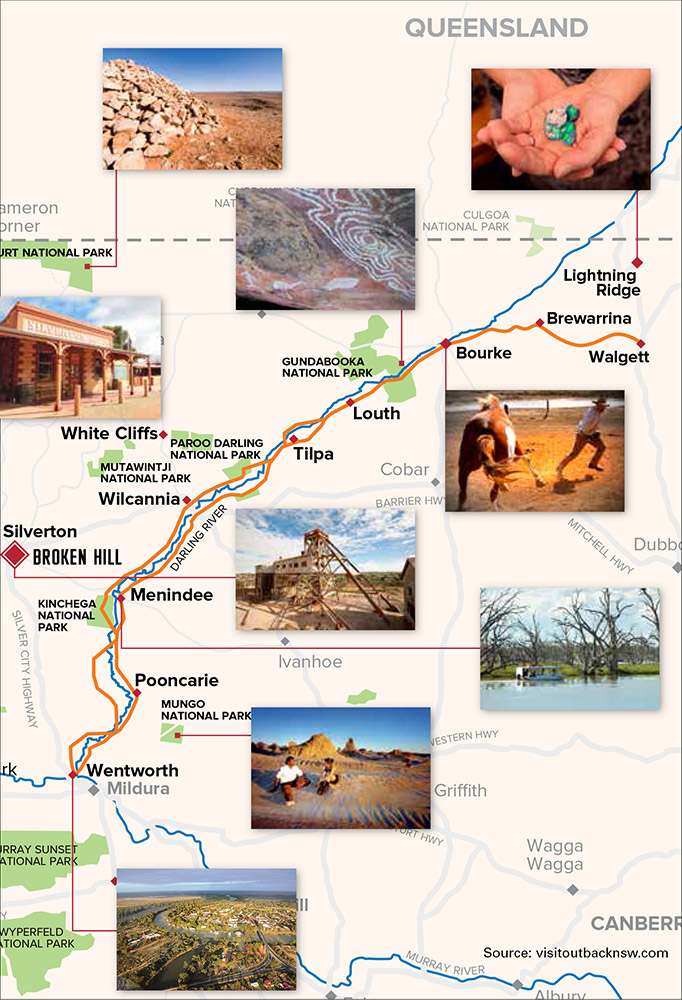
Wentworth
Today, Wentworth is a prosperous township with lots for the traveller to see and experience and is an ideal base to explore the amazing natural features of the area.
"Magnificent trees droop like willows to the waters edge with evening's mildest radiance in their foliage, throwing a soft haze over the distance ..." Charles Sturt 1844. Wentworth is located at the confluence of Australia's two great rivers, where the Darling ends and flows on as the Murray. Captain Charles Sturt, the first European to arrive here, 23 January 1830, tells in his journal of good communication with local Aboriginal peoples.
First settlers arrived around 1840 - a township was surveyed in 1858 and named Wentworth in 1859, after Australian explorer, journalist and prominent politician William Charles Wentworth.
Mainly, summer rains source the Darling, while winter rains and spring snow-thaw source the Murray, creating a unique situation of water all year round in the region where they meet.
William Randell and Francis Cadell captained the first two river steamers to race from the Murray Mouth to the area in 1853. Both rivers opened up for trade and Wentworth became the first river port on the Darling. By the late 1880's Wentworth was Australia's busiest inland port. In 1895, 485 vessels were recorded as passing through the Customs House (31 in one week alone). Wentworth, oldest town in the region, retains a village atmosphere with classic buildings and a central wharf precinct. Yet, just out of town you can be a child again, sand surfing in the red sand dunes known as Perry Sand Hills. You feel you are thousands of kilometers away from water, not just six kilometers out of town.
History buffs will learn from a visit to the Old Wentworth Gaol and Folk Museum (housing mega-fauna replicas), and hear of how district soldier settlers, using TEA20 Ferguson tractors, miraculously saved this town in the 1956 1-in-100 year flood.
Side Trip
Mungo National Park
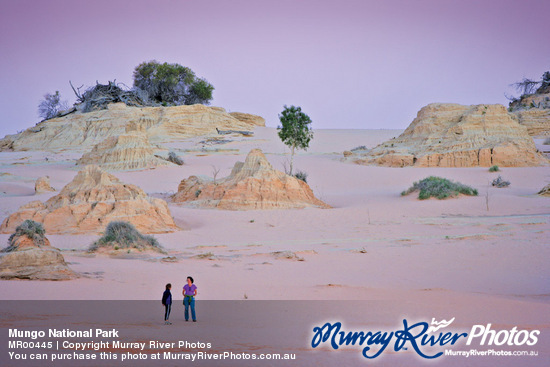
If you are to see one place in the NSW Outback it would have to be Mungo National Park and it's spectacular lunette, known as the "Walls of China."
It is the remnants of an ancient lake that is now completely dry and with ancient sand dunes running more than 20 km along one side. It is also one of the most significant anthropological and archaeological sites in the world. We recommend you take a guided tour with Harry Nanya Tours to fully appreciate what you are seeing and its significance in history and even human evolution. Located approximately 150km from Wentworth or 97km from Pooncarie. You can also see Mungo via an alternate route from Wentworth to Balranald or visa versa or from Mildura (Victoria).
Wentworth to Pooncarie
Originally gazetted as Pooncaira in 1863, the area was first 'established' by Europeans in the 1840's as settlers took up illegal livestock runs on crown land. By the 1860's the federal government, in an attempt to gain control of the area, formalised these illegal (and unfenced) claims.
The famous explorers Burke and Wills reached the Darling River at nearbyTarcoola Station and made camp at what is now Bilbarka Park in September 1860 on the way to their ill-fated expedition to the North West.
More settlers followed and the town established itself as a service hub for outlying stations and more importantly, at the time, a port for the paddle-steamer trade that was pushing up the Darling River. Visit the Old Wharf Site today in the banks of the Darling, via McKinlay street into Darling street. The highlight on the social calendar is the Pooncarie Cup held each October.
Pooncarie to Menindee
''There was Harrison, who made his pile when Pardon won the cup .... " so penned Banjo Paterson in the immortal poem 'The Man from Snowy River'. The 'Cup' actually refers to the Presidents Cup at Menindee and not the Melbourne Cup as many people have assumed.
Menindee is a town steeped in legend and history for Indigenous and European culture. The area was known to the Barkindji people as 'Minandichee' and it is believed this is how the name originated. Major Thomas Mitchell followed the Bogan and Darling Rivers down to this area in 1835 and came across the naturally formed Lakes which he named 'Laidley's Chain of Ponds' the Barkindji people referred to these as 'Wontanella' meaning 'Many Waters'. A decade later, explorer Charles Sturt travelled up the Darling from Wentworth though Menindee.
Australia's most famous explorers Burke and Wills passed through Menindee for their Melbourne to the Gulf of Carpentaria expedition. The expedition arrived at Menindee on October 14, 1860, and made camp at Kinchega Station after crossing the Darling River. A depot camp for the expedition was established at the Pamamaroo Creek (a sign and cairn mark the site of the camp). Upon their departure, Burke and Wills carved an arrow in the door post of the hotel to indicate the expedition's direction. This can be seen today outside the Maiden's Hotel in Menindee.
River boat trade continued to develop the area and plans for a weir to control the flow of the river and level of the lakes to ensure river traded were shelved in the 1890's and by the time the rail head reached the area in the 1920's the future of the river as a transport route were doomed.
The idea to control the flow of the river came to fruition in 1949 and completed in 1960 allowing for some retention of water in the naturally formed lakes to maintain sorne continuity for water supply and irrigation.
The Menindee Lakes originally comprised 9 natural ephemeral lakes covering an area of 453 km2. As a result of the weir, there areas major lakes Wetherell (including Lake Tandure), Pamamaroo (connected by a small lake called Copi Hollow), Menindee, and Cawndilla.
For the traveller, there is great fishing and bird watching on the lakes, the magnificent Kinchega National Park, Lake Pamamaroo and Main Weir, Copi Hollow, Menindee War Memorials, the 1872 wreck of the paddle-steamer 'Providence' and the self-guided heritage walk around Menindee, not to forget the birthplace of the Menindee Seedless Grapes ... vineyards are mainly on the north side of town.
The eastern journey from Menindee takes you 128krn before reaching the quaint town of Pooncarie. For more adventure and different scenery the western route takes you through the infamous Kinchega National Park and via Tandou Lake and then back throuqh Bindara Station to follow the Darling once more.
Menindee to Wilcannia
If there is one great, and largely undisturbed, port on the mighty Darling River it is Wilcannia. You will be amazed at the richness of the architecture in this town.
Here are the remnants of a once-important inland port. Some of the town's historic treasures include the old centre-lift bridge which was built in 1896 and is now classified by the National Trust, the beautiful 1880 post office and its attached residence, the Athenaeum Library (1883) and the impressive courthouse (1880), police station (1881), and the police residence (1880), which were all built of locally quarried sa ndstone and designed by James Barnet. In the peak seasons of autumn to spring, the area near the bridge is ideal for picnics.
Wilcannia is on the very edge of the New South Wales desert experiencing only 252 mm of rainfall per annum and often much of that rain will fall in violent, if short, desert storms.
Being at the juncture of the major east-west highway and the iconic 'Long Paddock' (The Cobb Highway which runs from Echuca-Moama on the Mighty Murray River), it is a great access point for the Darling River Run to continue upstream or downstream.
Travelling to Menindee on the eastern side of the river is 152km. The western side is the more frequently used road. This will extend the trip by 2km but brings you into town via the amazing oasis of Copi Hollow and the Explorer's tree at the Dam Wall.
Side Trip
Broken Hill / Silverton
The 'capital' of Outback NSW, Broken Hill, has everything the traveller could hope for. From 'city style' cafes, famous artists and their galleries, rich mining heritage with a variety of accommodation to refresh yourself amidst the journey.
Broken Hill and the historical town of Silverton, just 25km out of Broken Hill, can be combined in your itinerary in a number of ways. Include in your Corner Country loop or divert from Tilpa via White Cliffs to rejoin the run at Wilcannia. Or divert off the river at Wilcanni a to then Broken Hill and rejoin at Menindee.
Which ever way, Broken Hill is a great inclusion to the Darling River Run itinerary.
Wilcannia to Tilpa
'Tis said the land out West is grand, do not care who says it ~ Henry Lawson on 'The Paroo River' 1893. Located on the western banks of the Darling River, the very welcoming town of Tilpa is a must for a stopover, w hether you have a few hours or a few days for camping and/or fishing on the Darling River.
The old pub is a true classic and has been welcoming travellers and locals for over 100 years. The walls of this timber and corrugated iron Pub are covered with traveller's graffiti which makes for an intriguing read while having a cold beer and a chat to the locals and other fellow travellers. Visitors can add their own literary work or just sign their name for a small donation to the Royal Flying Doctor Service.
Originally a busy port servicing the river trade and local agriculture, it was a 'crossroad' in the Outback as the bridging of the river here served as a stock crossing and port for the wool clip being transported down to Wentworth and onto either Echuca or Adelaide. Tilpa is also famous for; the only Boer War Memorial that includes a commemorative to Harry (The Breaker) Morant, the shortest heritage trail in Australia comprising just two signs on either side of the main road, the cemetery is the only one in Australia with no one in it, and the Tilpa Trading Post (Shop) provides the traveller with many stores and also serves up the most unbelievable hamburgers - many say they are the best in the world!
Cross the river to the east and continue south-west on the Bourke - Wilcannia road for 137km. This is some of the most scenic driving along the Darling - not to be missed!
Louth to Tilpa
'a place that loved a drink, a party and a punt...' So wrote Henry Lawson.
Louth is a small service town (pub, fuel and general store) on the Darling River about 100km downstream from Bourke and 100km upstream from Tilpa. Normally a quiet and sleepy settlement, once a year it is the scene for an classic annual country race meeting in August each year and attracts travellers form far and wide to the 7 race event.
The town of Louth was created when TA Mathews established a Hotel to service the river trade and the Cobb & Co coaches that used it as a stop over. Nearby, the historic Dunlop Station was the first sheep station in the worl d to use mechanical shears.
Louth is ideally located for access to the Darling River Run and offers a choice of eastern or western route downstream to Tilpa.
Make sure you stop by the cemetery to witness the headstone that catches the light of the setting sun and reflects it through the town. On the birthday of "Mary Mathews (nee: Devine), who rests in this grave'; the reflected light is said to land on the front door of the house in which she lived.
Just over an hour on either side of the river will take you to Tilpa.
Side Trip
White Cliffs
A wonderful short side-trip to White Cliffs can be taken from Tilpa or Wilcannia. This trip takes you through the Parco-Darling National Park and onto one of the most amazi ng opal havens of Australia.
Famous for white opals, White Cliffs still house many miners that are currently finding their fortunes in opal. Stop by the National Parks Office or the General Store to pick up your free self-guided map of town.
An alternate route between White Cliffs and Broken Hill in dry weather is via Mutawintji National Park.
Louth to Bourke
"if you know Bourke, you know Australia" so wrote the famous Australian poet Henry Lawson in 1982. Bourke is not merely a town but a region that is the start of Outback Australia as anything to its west is referred to as the "Back o Bourke" a colloquial term etched deep in Australian language meaning to be a long way away from anything.
On the contrary, may be far away from 'civilisation' but the further out you go, the closer you get to the essence of this land. Maybe that is what Lawson was alluding. By the 1890's, Bourke was a major port for the transport of the South Queensland and North West NSW Wool clip that was transported down the Darling to the Murray River and onto Adelaide for ship transport overseas.
The Port of Bourke was the focus of the Worlds Wool industry with up to 80 riverboats service the region. The opening of the rail system in Australia and the unreliability of the river flow saw the gradual demise of the 'River Highway' by the early 20th century. This by no means spelled the end of Bourke and today it is a town that still, in essence, is the same as it was back then; a town on the edge of the wilderness with great historical, cultural and geographic significance.
Located where the Kidman Way meets the Darling River and a town firmly etched in Australian folklore, Bourke is the ideal access point for The Darling River Run. A true outback experience is available to those who visit Bourke.
Head out of town in a southern direction on the Mitchell Highway I Kidman Way. Just 4km out of town turn right on the Bourke-Wilcannia road (unsealed) and you follow the winding Darling River which is on your right hand side for 95km to Louth.
Bourke to Brewarrina
When you reach Brewarrina go down to the banks of the Barwon River and marvel at the ancient Aboriginal rock fish traps. Here is a reminder of the how important Brewarrina was for the local indigenous community. Not much further on is where the Darling truly begins. Brewarrina is known to the locals simply as 'Bre' It is said that the fish were so plentiful that there were times when as many as 5000 Aborigines gathered beside the river and amongst the fish traps to enjoy this rich harvest. Bre is still a fabulous fishing spot today but requires the new way of fishing with a line and bait. Set up camp beside the river with all the services close by.
Brewarrina was settled by Europeans in the 1840s who, by the 1860s, recognised it as the furthest point up the river for paddle steamers. As such it became an important port for settlers wishing to ship their wool to the coast. If you stop a while in Brewarrina, you will be surprised. The visitors centre is a great source of information.
Today Brewarrina is a quiet and peaceful town that welcomes visitors with open arms. Head further west for another 98km before you reach the magnificent port of Bourke.
Side Trip
Corner Country
The biggest loop for the Darling River Run is the Sturt's Loop which takes in Corner Country including Milparinka, Tibooburra, Mt Wood, and Wanaaring. Broken Hill or Bourke is the start or finish of this adventure and provides a great alternative and contrast to the Darling River Run. Please note part of this tour is on dry-weather roads. Please check the road conditions before travelling.
Bourke to Tibooburra is 417km or about 5 hours. Tibooburra to White Cliffs is 265km so you can rejoin the Darling River Run at Wilcannia or Tilpa. Broken Hill to Tibooburra i s 335km or about 4 hours.
Brewarrina to Walgett
Walgett, or as it's affectionately known "the gate'; is the gateway to the Opal Fields and the Outback. It is an ideal place to stay before heading off to the huge opal mining settlement of Lightning Ridge (76 km away) and the smaller opal fields at Grawin, Glengarry and the Sheepyard Opal Fields, all of which are located north-west ofWalgett. This area is the sense of the 'Outback' cleverly merged with the facilities and amenities of a larger country town. The Aboriginal meaning of " Walgett" is " meeting of two waters" as the town is located by the junction of the Namoi and Barwon Rivers. Walgett is 696 km north-west of Sydney and is the centre for the surrounding rural area which is based around the production of wool, beef cattle, fat lambs, sheep studs, chick peas and its biggest industry, wheat. In fact Walgett has the largest temporary wheat storage facility in the southern hemisphere. Its attractive riverside location also makes it an ideal spot for fishing: Murray cod and Yellowbelly being the predominant catches.
If you are interested in bird watching then a trip to Macquarie Marshes is a must. With private guided tours or time your trip around the annual Open Day for a treat.
Head west to Brewarrina (133km) to witness some of the most significant Aboriginal heritage in Australia.
Side Trip
Lightning Ridge
Thi s wonderful side-trip from the Darling River Run will take you to the iconic Australian Opal mining town of Lightning Ridge. Whether you are looking for the famous Black Opal, wanting to explore some wonderful galleries or just take in the experiences of a mining town, 'The Ridge' is a must. Its an easy drive to and from Walgett. As an alternate route, there is a nice drive via Cumborah to Brewarrina.
Lightning Ridge is 78km from Walgett or 180km from Brewarrina via Cumborah.
Suggested Itinerary - Walgett to Wentworth
These is a suggested self-drive 14 day tour of this real Australian experience or join one of our tours to have all the planning done for you.
Day 1
Arrive in Walgett, ready for the start of your Outback escape. Take the time to visit one of the main tributaries that flows into the mighty Darling further down the road. Fishing and bird watching spots surround Walgett or visit one of the Artesian Spas to truly start to relax.
Day 2
Walgett is the gateway to Opal Country, so a side trip to Lightning Ridge is a must. This Opal town is the only place in Australia where Black Opal is found. Try your hand at fossicking or visit one of the many attractions that the"Ridge"has to offer.
Day 3
Back on the road and take a scenic route to Brewarrina. Visit the oldest man made structure known in Australia; the Aboriginal "Fish Traps" which are visible today. Stop by the Visitors Centre to have a tour guide tell you the stories of yesteryear or view local Aboriginal Art.
Day 4
When the Darling River was used mainly for transport purposes in the late 1800's Bourke was one of the busiest ports on the Darling. Gundabooka National Park is only a stone's throw away and don't forget the Back 0 Bourke Exhibition Centre, which has only just reopened after a large extension to its exhibits
Day 5
Commence your run down the Darling to Louth, a tiny town with an amazing horse race event every year that sees the town grow by over 500% for 3 days. Accommodation is available at many of the amazing 'station stays; these are an experience on their own, steeped in history with magnificent water views from campsites.
Day 6
Tilpa is famous for its local 'pub' The proprietors pass on hundreds of dollars to the Royal Flying Doctor Service which are the result of visitors willing to donate a gold coin to write on the pub walls.
Day 7
The next day takes you to a town that has the most amazing architecture of all of Outback NSW. Wilcannia has some fabulous buildings that date back to the 1880's when it was a busy shipping port. Drop into Council to pick up your copy of the Historical Trail Guide.
Day 8
Divert off the Darling River Run to visit the capital of Outback NSW, Broken Hill! Be amazed by the city in the middle of the desert that still welcomes newcomers every year to settle in town. Abundant with mining history, art galleries, natural wonders and city style cafes or restaurants.
Day 9
A trip to Broken Hill is not complete without a trip to Silverton and out to Mundi Mundi Plains. Only half an hour out of Broken Hill, the lookout over Mundi Mundi convinces you that you can see for days. Watch the sun sink into the earth on sunset, an awe-inspiring experience.
Day 10
The oasis of the Outback is Menindee and its large lake system. This is where you rejoin the Darling River Run. Marvel at the amount of water that is stored in the middle of desert and how the lakes have regulated the flow of the river downstream to help agriculture. And don't forget to see where Menindee Seedless Grapes are grown ... yes, right here in the Outback!
Day 11
After frolicking in the water at Copi Hollow, Kinchega National Park is the next stop. This magnificent park surrounds the southern end of the lake system and is also the home to much history. The Kinch ega Woolshed is regularly photographed as one of the most indicative woolsheds of its time.
Day 12
Choosing which side of the Darling to travel from this point is the hardest decision you will make on the trip. Both sides offer fabulous scenery and things to see and do. Both roads will take you to the quaint town of Pooncarie; a sleepy little town that welcomes all visitors to share in their picnic havens by the Darling.
Day 13
A side trip to Mungo National Park can be included by diverting just after Pooncarie, or if you are travelling East back home, you can include after a trip to Wentworth. Either way, you can't miss the wonderful scenery created by the sand dunes of Mungo Lake. Make sure you stop by the visitors centre or have a tour of this national treasure to full appreciate its significance and value.
Day 14
Wentworth, where the Darling meets the mighty Murray! Stand at the confluence of the two great rivers and be amazed by the abundant bird life and colours of the water. Only 6 kilometres out of town, Perry Sand Hills offers an amazing contrast to the river and great for photography or having a bit of sand fun.
Five Darling River facts you might not have known:
1. Fish can climb ladders
Fishways (or fish-ladders) provide passage for fish normally stranded at the base of a weir. Fishways allow them to move along rivers to feed and breed, resulting in increased native fish numbers. The Western Catchment Management Authority (CMA) is supporting the installation of fishways at the Brewarrina and Bourke weirs.
2. Charles Sturt originally named the Darling 'Salt River'
Salinity is not a new phenomenon. Naturally underground flows of salty water enter the Darling at several points including the one where Sturt attempted to water his horses in 1829. Salinity is bieng managed by protecting and rehabilitating waterways and native vegetation, changes in land and water management and engineering works.
3. Tilpa means 'floodwaters' in the local Aboriginal Baakindji language
Floodplains operate in large flood wevents where the river breaks out of its banks. Due to the flat nature of the Western Catchment, floodwaters can slowly spread for tens of kilometres across the landscape, rejuvenating the plant and animal life of the area and enabling fish breeding to occur.
4. 80% of Murray Cod are found within 1 metre of a snag
Snags are the inland equivalent of marine reefs. Trees and branches that have fallen into the river habitat, feeding and spawing sites and shaded resting areas. The Western CMA has re-introduced snags to encourage native fish numbers, replacing the snags removed during the days of the paddle steamers.
5. The Western Catchment supports 471 animal species and 1,351 plant species
One species is the iconic Red-tailed Black Cockatoo (Calyptorhynchus banksii), which is listed as a vulnerable species. They nest in the hollows of mature River Red Gums (Eucalyptus camaldulensis) along the Darling. The Western CMA assists in protecting and re-establishing riverbank vegetation, some of which will become homes for future generations of these magnificent birds.
The Darling River is the lifeblood of Outback NSW. Only 15% of the Darling's water comes from within the Western Catchment. It belongs to a complex system with highly variable flows which are affected by actions upstream.
To learn more during your Darling River Run experience, watch out for Western CMA educational signs at Wilcannia, Tilpa, Louth, Bourke, Brewarrina, and Lightning Ridge.
Visit www.western.cma.nsw.gov.au for information about the Western CMA's work in the 230,000 km2 Western Catchment, incluing management of land and native vegetation, other river systems, biodiversity and our cultural heritage.
Darling River Run website
![]()

Tell your friends you found this at murrayriver.com.au!
Copyright Discover Murray 2026. This site or any portion of this site must not be reproduced, duplicated, copied, sold, resold, or otherwise exploited for any commercial purpose that is not expressly permitted by DISCOVER MURRAY.