


 Song Sung Blue. The Neil Diamond Experience featuring Troy Harrison. A Story in Every Song.
06 Mar 2026 - Renmark
 Ireland The Voyage
24 Feb 2026 - Renmark
 Cirque Nouvelle
14 Apr 2026 - Renmark
 Kevin Bloody Wilson Aussie Icon Tour with special guest Jenny Talia
27 Mar 2026 - Renmark
 The Australian Beach Boys Show
03 May 2026 - Renmark
On a large bend in the Murray, Berri has a couple of wrecks
 Berri
Berri
Berri lies on a large bend in the Murray, one of many such twists and turns that challenged riverboat skippers navigating this stretch of the waterway.
The town was officially established in 1911 but before then a few independent settlers had developed small-scale holdings in the area and welcomed the passing river boats. Some enterprising groups had even established woodpiles on the river banks to provide fuel for the steamers.
Fruit-growing was successful on the irrigated blocks and the Berri Co-op Ltd was established in 1916. The town's population increased in the 1920s and 1930s with an influx of returned soldiers and paddle steamers called regularly to collect the area's dried and fresh produce for shipment to the Adelaide markets.
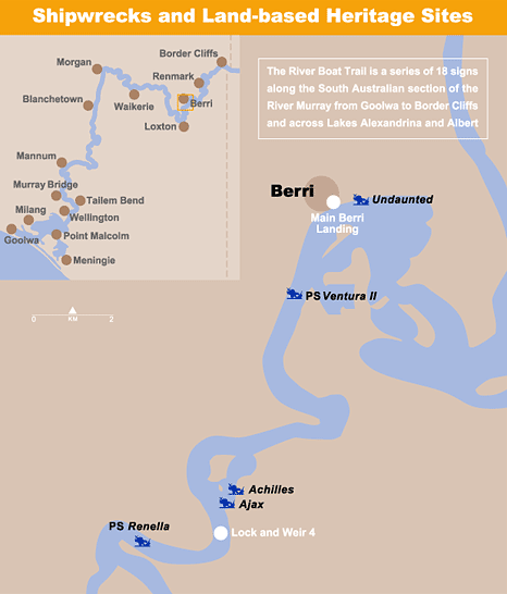
River Wrecks
Barges Ajax and Achilles
Structural remains of these barges are generally visible a short distance above Lock No. 4, where they were abandoned near the bank. Both vessels were built at Murray Bridge and worked for the E&WS Department of South Australia.
Undaunted
From its construction as a side-wheeler in 1875, the Undaunted was converted a number of times to a barge, a motor vessel and a two-masted ketch working on Lake Alexandrina. It was broken up near the Berri Pumping Station.
Fishing Boats on the Murray
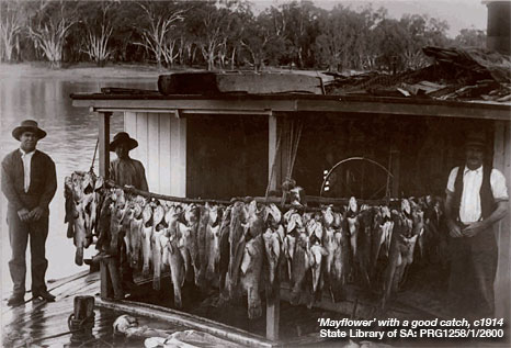 Professional fishermen worked and lived along the river. While farms and orchards were being established, the government gave some of the settlers exclusive rights to fish certain reaches, thereby supplementing their diet and income.
Fishing rights were also granted to ex-servicemen and others who simply wanted to be professional fishermen.
Catches were sent off to Melbourne or Adelaide, although often they were rotten before reaching their markets. Passing passenger steamers also brought fresh fish for their dining rooms. Some fishermen made a good living catching leeches for Adelaide doctors.
Many of the fishermen worked and lived on small steamers with half-submerged punts tied to the sponson. Fish could be kept alive in these open punts, but they were also a temptation for anyone wanted a free meal.
As the fruit blocks were established and farms developed, the right to the reaches were let go and professional fishing gradually declined after the 1940s.
GPS: Zone 54 E 0463484 N 6205850
Panel is next to the Berri Visitor Information Centre (on the bridge side)
Interpretive panels are located at:
River Boat Trail | Border Cliffs | Renmark | Berri | Loxton | Waikerie | Morgan | Blanchetown | Mannum
Murray Bridge | Tailem Bend | Wellington | Meningie | Point Malcolm | Milang | Goolwa
Please do not interfere in any way with ship-wrecks and land based heritage sites
Published with permission of Government of South Australia
Department for Environment and Heritage

Tell your friends you found this at murrayriver.com.au!
Copyright Discover Murray 2026. This site or any portion of this site must not be reproduced, duplicated, copied, sold, resold, or otherwise exploited for any commercial purpose that is not expressly permitted by DISCOVER MURRAY.