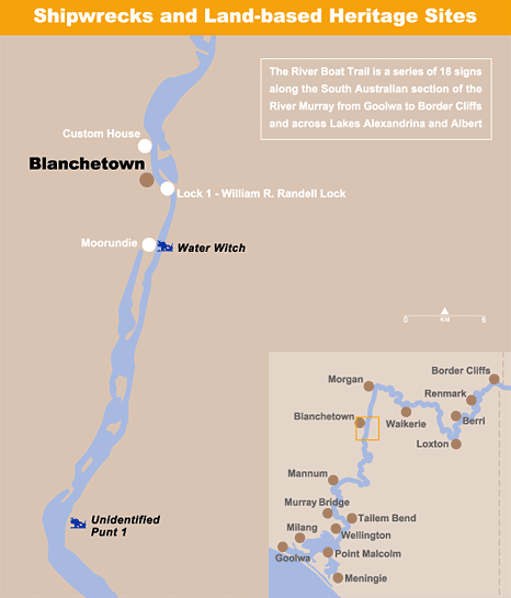
Blanchetown is home to Lock No. 1. The first on the Murray.
 Blanchetown
Lock & Weir No. 1
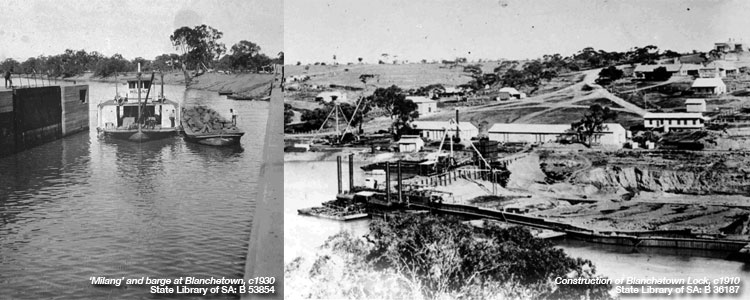
Completed in 1922, this was the first of the series of locks and weirs that provided year-round navigability for river boats below the junction of the Murray and Darling Rivers.
Officially known as Lock and Weir No. 1. Blanchetown's lock was named for William R. Randell, the Murray's pioneer captain, who first navigated the river in 1853.
It is the River Murray's longest weir at 168.85 metres and includes a navigable pass and a sluice section, both of which can be opened during floods to maintain water flows. The associated lock allows boats to move from one level of the river to another.
The foundation stone was laid on 5 June 1915, but because of floods, it was December 1919 before the lock valves were opened. The lock was officially opened to river traffic on 5 April 1922. Some 60,000 tones of stone had been used in its construction.
A Navigable Waterway
From the 1850s the Murray developed as a major transport route with shallow-draught paddle steamers towing barges loaded with wool, grain and other produce. In its natural state the Murray was quite different from the river of today. Prolonged droughts uncovered sandbars and snags or turned some parts of the river into a series of salty waterholes.
A succession of droughts from 1895 to 1902 emphasised the problems and rivermen pushed for the construction of weirs to provide a reliable source of water along the river's length.
A lock was included at each weir because South Australia was determined that cargo and passenger vessels should b able to travel the length of the river.
Although the river trade was soon replaced by rail and motor transport, the locks are maintained and operated today to benefit the increasing number of houseboats, tourist cruise boats and recreational craft that navigate the Murray River.

PS Captain Sturt
A number of new boats and barges were required for the construction of the River Murray locks and weirs. Twelve wooden and two metal barges were built, with the most significant being the stern-wheeler Captain Sturt.
This powerful steamer was built in the United States, imported into South Australia in sections and assembled at the Mannum quarry from 1915-16. After the hull was re-assembled and the engine installed, the Captain Sturt was brought to Blanchetown where the superstructure, decks and cabins were completed.
From 1917 until 1935, the Captain Sturt delivered barges of crushed granite from the Mannum quarry to the construction sites of all locks from Blanchetown to Lock 9. with a top speed of ten knots, the steamer moved an average load of 500 tons and is estimated to have delivered 220,000 tons of material during this time.
The Captain Sturt was similar to the Mississippi river boats. Rather than towing, it actually pushed the loaded barges - usually three at a time. In its 18 years on the job, the steamer was never snagged and is reported to have 'lost' only two loaded barges.
In 1935, with the locks nearing completion, the Captain Sturt assisted with the construction of the barrges at the Murray Mouth. In 1940, once the barrages were built, this large river boat was sold and converted to a houseboat at Goolwa.
Moorundie
South Australia's earliest Murray River settlement
In 1841 Edward John Eyre was appointed Resident Magistrate and Protector of Aborigines on the River Murray. He established the post on his Moorundie property, which was 6 km downstream from the site.
A detachment of soldiers supported Eyre and lived under canvas while stone barracks were built.
Adjacent land became the village of Sturt. In 1842, the settlement had a population of 43 and comprised stone buildings as well as several timber houses.
Eyre cultivated the land and constructed irrigation channels beside the Murray. When he returned in 1844 his timber house was dismantled.
In 1846 the soldiers were withdrawn, as they spent their time mainly fishing and hunting. The barracks building became the police station, of 3 rooms and a lock up. It was located close to a stone jetty.
The village of Sturt survived until 1856, when it was abandoned because of continuous flooding.
At that time the soldiers' barracks, police station and two or three houses were left standing. Today only low walls, footings and collapsed ruins remain.
The ruins at Moorundie are significant State Heritage Place protected by the Heritage Places Act 1993.
Water Witch
Oldest wreck on the Murray
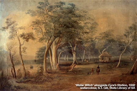
 The Water Witch, one of South Australia's most historic shipwrecks, is located six kilometres downstream, adjacent to the ruins of Eyre's station at Moorundie. This small cutter was the first documented vessel to sail through the Murray Mouth and is the River's oldest wreck.
Built in Hobart Town in 1835, the Water Witch traded around Australia's coast until 1839, when it was purchased by the South Australian government and fitted out for the colony's first Marine Surveyor, Captain William Pullen. It assisted in surveys of Encounter Bay, the Murray Mouth and the upper Spencer Gulf, and carried Governor Gawler during his inspections of Port Lincoln an Rapid Bay.
Notably, the Water Witch also assisted Edward John Eyre during his explorations of South Australia's far north and later across the Nullabor.
In June 1840 the cutter took his supplies to the head of Spencer Gulf and later assisted his east-west crossing of Australia.
In May 1841 the Water Witch became the first vessel to successfully sail through the Murray Mouth and intso Lake Alexandrina.
A few months later the cutter was in poor condition at Wellington an was transferred to Eyre's river-front property at Moorundie. It then lay idle until it sand at its moorings during a storm in December 1842.
An Archaeological Treasure
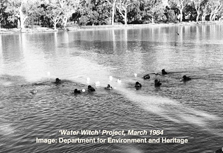
 In the early 1980s, recognising the Water Witch's historical and archaeological importance, members of the society for Underwater Historical Research carried out extensive underwater surveys to locate any remains.
Initial searches were unsuccessful, but the discovery of an early pen and ink drawing made it possible to pinpoint the location of a sailing vessel at Eyre's settlement in 1842.
By comparing the existing eucalypts and river bank with the landscape shown in the drawing, divers quickly located wreckage that was later identified as the remains of the Water Witch.
These remains are a tangible link with the early exploration of South Australia, and provide valuable insights into early Australian shipbuilding techniques and materials. Timber frames, planking and fittings were found in the river silt. Many artefacts, including a stove and a ceramic toilet bowl, were recovered and have been displayed in local museums. Most of the hull structures remains on the river bed.
| Lock & Weir GPS: Zone 54 E 0372681 N 6197970 Panel downstream of the lock, in the riverfront park off Shaw Street |
Water Witch & Moorundie GPS: Zone 54 E 0372695 N 6197958 Panel downstream of the lock, in the riverfront park off Shaw Street |
Interpretive panels are located at:
River Boat Trail | Border Cliffs | Renmark | Berri | Loxton | Waikerie | Morgan | Blanchetown | Mannum
Murray Bridge | Tailem Bend | Wellington | Meningie | Point Malcolm | Milang | Goolwa
Please do not interfere in any way with ship-wrecks and land based heritage sites
Published with permission of Government of South Australia
Department for Environment and Heritage
Tell your friends you found this at murrayriver.com.au!
Copyright Discover Murray 2026. This site or any portion of this site must not be reproduced, duplicated, copied, sold, resold, or otherwise exploited for any commercial purpose that is not expressly permitted by DISCOVER MURRAY.


 Lewis Major: Triptych
 Ireland The Voyage
 The Australian Beach Boys Show
 Cirque Nouvelle
 Song Sung Blue. The Neil Diamond Experience featuring Troy Harrison. A Story in Every Song.